
Center for International Forestry Research
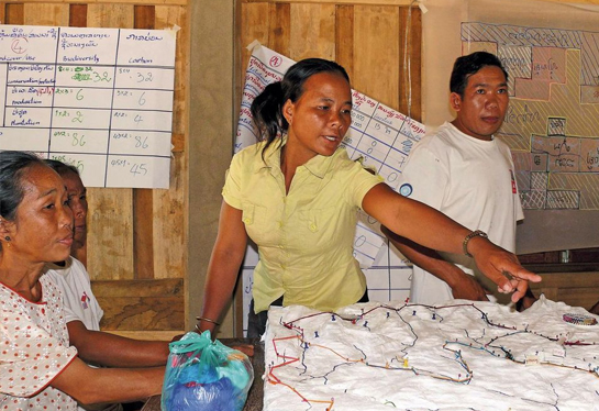
Role-playing and 3D mapping help communities get involved in landscape planning
Well-intentioned plans are too often abandoned and forgotten when villagers are left out of the land-use planning process.
Conversely, by placing a 3D map (complete with familiar landmarks) in the middle of a table and asking residents what they would do as a developer, conservationist or village leader, it suddenly becomes easier to incorporate local views into the process.
In former styles of land-use planning meetings, local people would usually just sit at the back of the meeting room waiting for it to end.
Jean-Christophe Castella
Researcher
This role-playing tool, devised by CIFOR scientists and partners, helps village communities see the long-term advantages of careful landscape management. The method was initially tested in 2011 in 28 villages that border the Nam Et – Phou Loey National Protected Area in Laos, one of the few remaining sanctuaries for tigers in the country. 3D mapping has since been picked up by 10 different districts and is being implemented in about 300 villages.
The results, so far, are very promising, said Jean-Christophe Castella, one of the researchers.
In the past, villagers often ended up implementing plans that they did not understand and that were doomed to fail. “In former styles of land-use planning meetings, local people would usually just sit at the back of the meeting room waiting for it to end,” Castella said.
When leaders from all of the local villages are in the same room together, demarcating their borders on the 3D maps, they are able to resolve territorial disputes and arrive at a group consensus, he said.
The learning tools address barriers such as the language gap between planners and communities, low map and reading literacy, and limited community understanding of the impacts of land-use plans.The meetings also help train local people in negotiation skills so they are better equipped to discuss future land use and resource management plans in their area.
Mr Monsay Laomouasong, the Governor of Viengkham district in Luang Prabang Province, where the initial trials took place, was pleased with the results so far. “This approach puts the keys of development in the hands of local communities and avoids engaging them in endless assistance programs,” he said.